For general help on OSM Overlays, see the documentation: DE / EN.
- OpenLayers: (EN / DE) "is an open-source implementation of a “Slippy Map” interface. It is a JavaScript library released under the BSD license. It is one of several libraries you can use to deploy your own slippy map on a website." – Examples
online form to add points to a map
interactively

With this online tool you can add new points and export the image link in several formats.
- find NPP listed in the nuclear-heritage.net-wiki
- search for location on openstreetmap
- choose ‘add new point’ and click on the map
static using Openlayers
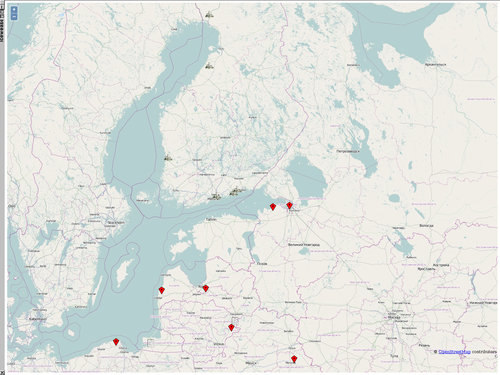
Download the attached files map.html, npp-coords.txt, nuclear_power_plant.png to one folder and open the map in your browser. It will show the map with some of nuclear power plants around the baltic sea.
POI are defined either statically with a textfile in this format or can be loaded from a SQL database. The map is included with some little javascript.
- npp-coords.txt
lat	lon	title	description	icon	iconSize	iconOffset
65.93093	24.30176	Simo (Finland)	<a href="http://www.nuclear-heritage.net/index.php/Simo" target="_blank">wiki</a>	nuclear_power_plant.png	30,30	0,-24
64.41844	24.30176	Pyhäjoki (Finland)	<a href="http://www.nuclear-heritage.net/index.php/Pyhäjoki" target="_blank">wiki</a>	nuclear_power_plant.png	30,30	0,-24
61.48354	21.40137	Olkiluoto (Finland)	<a href="http://www.nuclear-heritage.net/index.php/Olkiluoto_NPP" target="_blank">wiki</a>	nuclear_power_plant.png	30,30	0,-24
60.18794	24.83182	FiR 1 Research Reactor (Otaniemi/Espoo, Finland)	<a href="http://www.nuclear-heritage.net/index.php/FiR_1_Research_Reactor" target="_blank">wiki</a>	nuclear_power_plant.png	30,30	0,-24
60.4271	26.2154	Loviisa (Finland) <a href="http://www.nuclear-heritage.net/index.php/Loviisa" target="_blank">wiki</a>		nuclear_power_plant.png	30,30   0,-24
60.52523	26.47646	Ruotsinpyhtää NPP (Finland) <a href="http://www.nuclear-heritage.net/index.php/Ruotsinpyht%C3%A4%C3%A4_NPP" target="_blank">wiki</a>	nuclear_power_plant.png 30,30   0,-24
59.9167	30.2500	Leningrad NPP (St. Petersburg, Russia) <a href="http://www.nuclear-heritage.net/index.php/Leningrad_NPP" target="_blank">wiki</a>	nuclear_power_plant.png 30,30   0,-24
59.8773	29.0851	Sosnowy Bor NPP (Russia) <a href="http://www.nuclear-heritage.net/index.php/Sosnowy Bor NPP" target="_blank">wiki</a>	nuclear_power_plant.png 30,30   0,-24
56.8684	24.3613	Salaspils Research Reactor (Latvia) <a href="http://www.nuclear-heritage.net/index.php/Salaspils_Research_Reactor" target="_blank">wiki</a>	nuclear_power_plant.png 30,30   0,-24
56.8004	21.2671	Pāvilostas NPP (Latvia) <a href="http://www.nuclear-heritage.net/index.php/P%C4%81vilostas_NPP" target="_blank">wiki</a>	nuclear_power_plant.png 30,30   0,-24
54.050	30.591	Ostrovets NPP (Belarus <a href="http://www.nuclear-heritage.net/index.php/Ostrovets_NPP" target="_blank">wiki</a>	nuclear_power_plant.png 30,30   0,-24
55.33990	26.16140	Ignalina NPP (Lithuania) <a href="http://www.nuclear-heritage.net/index.php/Ignalina_NPP" target="_blank">wiki</a>	nuclear_power_plant.png 30,30   0,-24
55.5976	26.4320	Visaginas NPP (Lithuania)	<a href="http://www.nuclear-heritage.net/index.php/Visaginas_NPP" target="_blank">wiki</a>	nuclear_power_plant.png 30,30   0,-24
54.70664	20.51052	Kaliningrad NPP (Russia) <a href="http://www.nuclear-heritage.net/index.php/Baltic_NPP" target="_blank">wiki</a>	nuclear_power_plant.png 30,30   0,-24
54.7594	18.0581	Jezioro Żarnowieckie NPP (Poland) <a href="http://www.nuclear-heritage.net/index.php/Jezioro_%C5%BBarnowieckie_NPP" target="_blank">wiki</a>	nuclear_power_plant.png 30,30   0,-24
<a href="" target="_blank">wiki</a>	nuclear_power_plant.png 30,30   0,-24
- map.html
<html><body>
  <div id="mapdiv"></div>
  <script src="http://www.openlayers.org/api/OpenLayers.js"></script>
  <script>
    map = new OpenLayers.Map("mapdiv");
    map.addLayer(new OpenLayers.Layer.OSM());

    var pois = new OpenLayers.Layer.Text( "My Points",
                    { location:"./npp-coords.txt",
                      projection: map.displayProjection
                    });
    map.addLayer(pois);

    //Set start centrepoint and zoom
    var lonLat = new OpenLayers.LonLat( 21.26953125, 60.525022660959 )
          .transform(
            new OpenLayers.Projection("EPSG:4326"), // transform from WGS 1984
            map.getProjectionObject() // to Spherical Mercator Projection
          );
    var zoom=11;
    map.setCenter (lonLat, zoom);

  </script>
</body></html>
URL
If you have the coordinates of an NPP already you can edit the image url directly. Add the following line to the URL.
&mlatX=65.93092863127&mlonX=24.3017578125(‘X’ represents the number, which obviously should be the last number used + 1)
The syntax for the whole URL follows this scheme
http://ojw.dev.openstreetmap.org/StaticMap/?lat=60.525022660959&lon=21.26953125&z=5&w=964&h=716&layer=hiking&mode=Export&zoom_to_clicks=off&show=1&mlat0=65.93092863127&mlon0=24.3017578125&mlat1=64.418435776563&mlon1=24.3017578125&mlat2=61.48353941457&mlon2=21.4013671875
Layered maps for Mediawiki
use OSM with mediawiki (slippymap is outdated)
Extensions:Maps + SemanticMediawiki
- Example
{{
#display_map: 55.7557860, 37.6176330
| service=openlayers
| layers=osm-mapnik, osm-cyclemap, osmarender
}}
Installation
Requires Mediawiki 1.18. NH uses 1.19.
Once you have downloaded the code, place the Maps directory within your MediaWiki ‘extensions’ directory. Then add the following code to your LocalSettings.php file:
# Maps
require_once( "$IP/extensions/Maps/Maps.php" );
Semantic Maps.
To further enhance the map, Semantic Mediawiki is needed.
Map data then can be exported in several formats, like KML (WP).
For further use they can be translated to GeoJSON with togeojson: mapbox.github.io/togeojson
- The useful list used by grazwiki.at is long. They enable to add questions to your wiki pages:
{{
#ask:
[[Koordinaten::+]]
[[Kategorie:aktuell]]
| ?Koordinaten
| format=openlayers|width=100%|height=300|icon=nachbar.png
}}
installation
usage
- basic example
{{#display_map:new york city
| layers=osm-mapnik, osm-cyclemap,  bing-hybrid
| service=openlayers
}}
standalone map software
- combine dspace compatibility with modestmaps (chron0), leafletjs (elf) + neokarto
- cors, leafletjs
Wiki tasks
- in the Wiki add the template to all NPP pages, like for Olkiluoto
- currently the NPP category is mixed with NukeNews and should be separated.


